Tuesday, April 29, 2014

Hopkinton Site in LIDAR

Last month when I read about the Hopkinton site on the Rockpiles blog, I made some LIDAR images of the area.  I have never been there, and wanted to see what features I could find for a later visit.  Here are the best LIDAR images.  If anyone would like LIDAR images for illustrating the features of this site, I would be glad to send them in JPEG or TIF format.  Close-ups and different views can be made from the source data.


The area to the lower left in purple has plenty of walls and rounded structures indicating boulders and large rock piles.  The conical objects are tree artifacts.  The details are lined out below.


Dirt roads are dotted lines, and the walls are drawn in at lower left. The Z-axis was slightly exaggerated to bring out details. The area directly south also has many stone walls.  The larger square objects are houses.


Here it is marked.


The view directly west of the first area shown  has a road lined with houses. This area is also strewn with boulders.


The LIDAR data files used to generate these images are too large to be tiled together for a continuous image.

Wednesday, April 23, 2014

Manitous in the Break Room at Work


    One day I was looking through a soap opera digest magazine at lunch, just to have something to look at, when I came upon this Outward Bound ad.


In the center are some slabs resembling manitous.


There was something very familiar about this landscape, and then I remembered.  This was nearly the same scene in this watercolor, The Tetons,  painted by Thomas Moran in 1874.


It looks like Moran used a  different angle, in which the manitous are not visible.  Oh, if only he had documented them! Assuming this is the correct location, the painting is a scene in the Absaroka  Mountains in present day Yellowstone National Park.  A search of hiking trails in the Absarokas turned up some hikers' blogs, with pictures of these same manitous on Black Mountain. Alas, what they say about the internet is not true:  photos posted there are not available forever!

Watch this slide show for  manitous in the Absarokas here
Also check out this story about cairns in the Absarokas here

Wednesday, April 16, 2014

Return to the Corner

I was so embarrassed by the washed-out photo of a propped boulder that I posted 3/26/2014, I went back and took some more.  This is a large propped boulder on an outcrop, and with two other propped boulders it comprises  a "corner" .  It has some very interesting details, such as  four small rocks wedged in a small space underneath.


It also has an oddly mouth-like gash. The other end of the boulder has a tail-like protrusion resting on a large stone.


The sharp edges and planes in this boulder suggest it was  deliberately shaped this way.  The boulder looks like a tadpole.  Maybe it was once an effigy or totem. There are a few other boulders on this outcrop, but none  are propped.


Further along on  the hill stands an interesting structure consisting of two large vertical boulders, and a flat one, which is seen to the right.


The flat one is propped.


This is reminiscent of the site shown 1/15/2014.  It is about 15 miles away and also has a flat, propped boulder surrounded by  taller boulders  at the crest of a hill.


These hilltops both  have propped boulders and grinding slicks, and were  probably once  Native campsites.  These structures may have once been  work sites or meeting places. One thing that both these hilltop sites lack is cairns.


There are some neatly organized cairns in a level area 700 feet away and downhill from the strange, tadpole-shaped propped boulder.  If these were also built by the Natives, they were placed well away from living and work areas on the hill. On my way back to the road, I saw a ray of afternoon sun light a large chunk of quartz on a low cairn . This makes it easy to imagine a memorial on a long-forgotten grave.


Wednesday, April 9, 2014

Neutaconkanut Hill

     Sunday afternoon I went to Neutaconkanut Hill.  This large hill on the line between Providence and Johnston, RI, was very important to the Narragansetts.  The original land transfer to Roger Williams named it as one of the boundaries.  Over the centuries it has been farmed, used as a park, a ski slope, and a neighborhood dump. Now the wooded crown is maintained as a green spot in an urban environment.


There are stone rows wandering across the steep slopes.


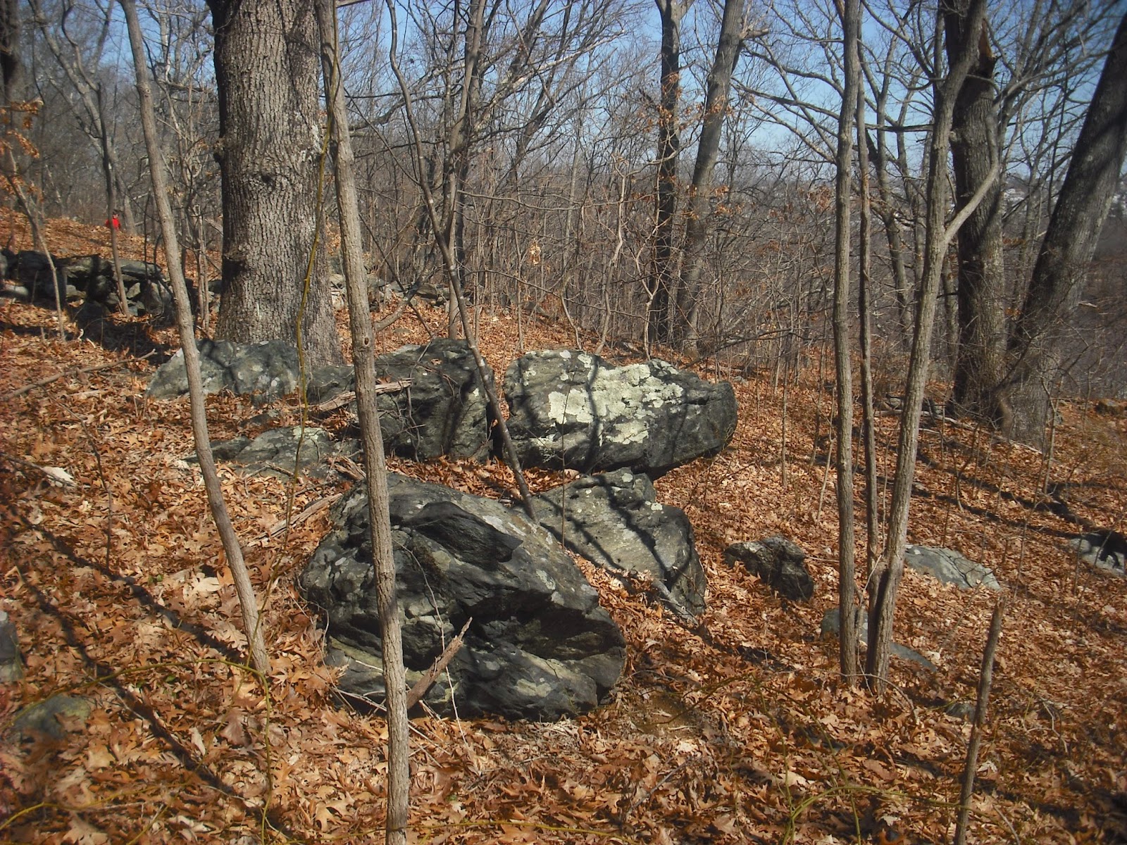
There is also a swamp near a single propped boulder I have shown before (10/16/2013).


In the 1990s the swamp was cleaned of over 100 old tires, and a jeep that had been stolen in North Carolina in 1978.  The owner didn't want it back.  Downhill from this outcrop stands a squarish boulder filled with leaves and twigs.  Cleaning out the debris reveals a rough cavity.


Maybe this was once a mortar used to crush acorns for soaking the in the water.  The presence of plenty of oak trees certainly is suggested by the name Neutaconkanut, which means "place of squirrels".
     A little further down the trail is this bent tree.


Obviously, this tree was bent only a few decades ago.  There are two others having this size and shape on the hill.  This afternoon I notice that it seems to point down this straight opening in the trees.


Old paths persist because the earth is compacted,  slowing the growth of vegetation. At the end is a short line of  rocks overlooking a small pond.


Whatever purpose or significance these stones had is lost.  The significance of this pile of rubble is not lost.


This is what remains of Canonicus Rock, a huge glacial erratic that was destroyed in the 1950s out of fear it would fall into Hartford Avenue below.  They may have dynamited it, but the pointer 90 feet away is still facing south.


  Finally, a visit to the Pinnacles, some huge manitou-shaped spires on an east-facing slope.


And my favorite view.


It is always surprising to see the dense urban sprawl of Providence after  wandering this apparent wilderness of stone rows and boulders.


Thursday, April 3, 2014

The Snow Squall

A few weeks ago I showed a massive perched boulder on a hill in western RI.    Many of the propped boulders I have found are huge stones resting on hilltops, where they would be seen for miles.
     This massive propped boulder is on the east side of a steep hill and has been a target for graffiti artists (4/1/2014).


Half a mile away is another hill, crowned with this propped boulder.


Because of heavy tree cover, these boulders are not visible from a distance.  The Natives used to manage forests with planned burning, so these boulders were probably clearly visible during their time. Luckily, this area was LIDAR imaged, so I constructed a three-dimensional model from the data.  Grass GIS allows manipulation of the 3-D models as to bearing, altitude, and light direction.


This would be the view from the top of the hill with the first boulder, looking towards the other boulder.  The LIDAR data covers a square mile, so there is no distant landscape.   Those conical objects are artifacts from water reflections in a swampy area.  The light  is from the southwest, as in a winter afternoon.  Some of the larger boulders are visible on the hill.  Having a rainy Sunday, I used the model to make this painting of a  snow squall passing a winter camp, seen from the hill with the first boulder.


 The massive squarish propped  boulder is on top of the other hill, and a Native long house is visible in a protected sunny spot at the foot of the hill. A stream runs through a rocky bank to marshes at the far right.

Tuesday, April 1, 2014

The Story is in the Details

Recently I visited one of my favorite hilltop sites.  This one has two large propped boulders, which have a direct N-S alignment which I have shown before (7/24/13).  I was looking for the third propped boulder.  Here are the candidates:


It's in the right position; maybe it's a propped boulder that broke.   It has a cavity underneath.


Here's another possibility, a boulder  with an inverted triangle shape perched on a rocky outcrop. The shape is similar to the two propped boulders on this hilltop.


      The details of this site tell a greater story.  Here is a stone wall leading into the site, near the broken boulder shown above.


As I mentioned previously, I wonder if these boulders were used as boundaries  in land transfers. 
The larger propped boulder has a commanding view from the  hill, which unfortunately has made it a target for graffiti artists. 


The stone directly to the left of  it has an interesting feature: a shallow circular depression on its flat top surface.  There are two faintly visible, concentric rings. Unlike natural, eroded depressions, this one is very symmetrical.   Maybe this was once a work surface, and its location  afforded a good view of the surrounding area.


The best find of the afternoon was directly downhill and 250 feet from this boulder.


This stone is about two and a half feet across, and has a very smooth, slightly concave surface.  Note the sharp, bright  edge  to the left in the photo.  This may have been a grinding slick. The proximity of grinding slicks and mortars to propped boulders suggests these were important markers for campsites and villages. Cairns and rock piles are scarce  in these sites.  The Natives probably did not build cairns in their residential and work areas.