Wednesday, October 31, 2012

Quarried boulders

Hidden deep in the woods of northern RI is a forgotten boulder quarry, with a few cairns.  The boulders were quarried with metal tools.
 Large slabs and curb stones were left lying where they were cut from boulders.  There was no need to expend the energy to move them  until they were needed in construction.
All around in this field are piles of rock. Some look like they were created as sorting piles for the quarried rock, while others look like platform cairns. The  pile below consists of large, squarish pieces of rock.

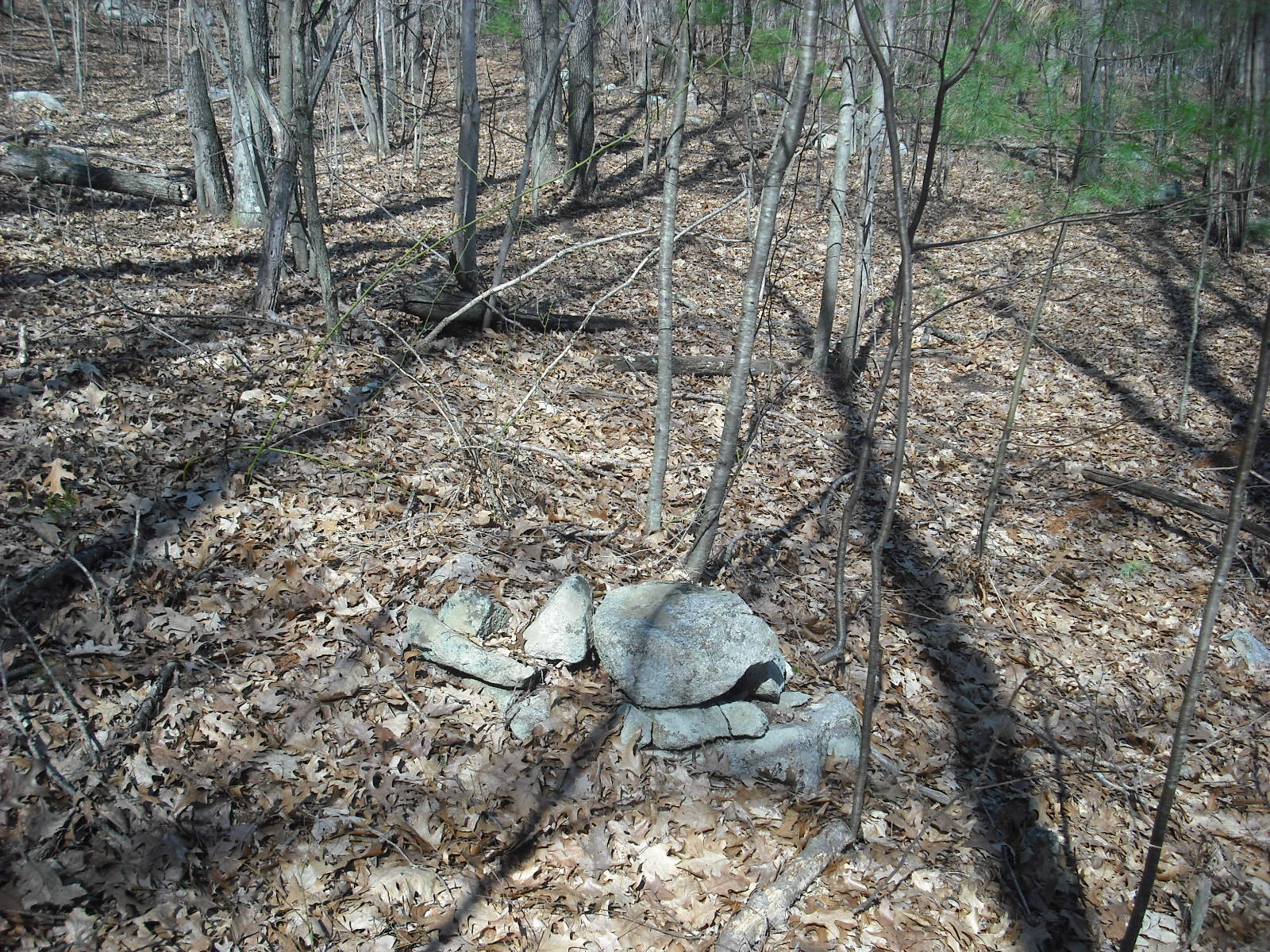
  The piles were probably created next to the quarried boulders, and some of the stones may be left on top of the buried remnant of the boulder. Some of these piled stones are too small to be of much use in construction.
 However, such small stones can be used to fill in gaps in stone walls.
There are many stone walls in the area surrounding this boulder quarry. The closest is about 115 feet from the piled stone, suggesting the boulders were quarried to build these walls. 
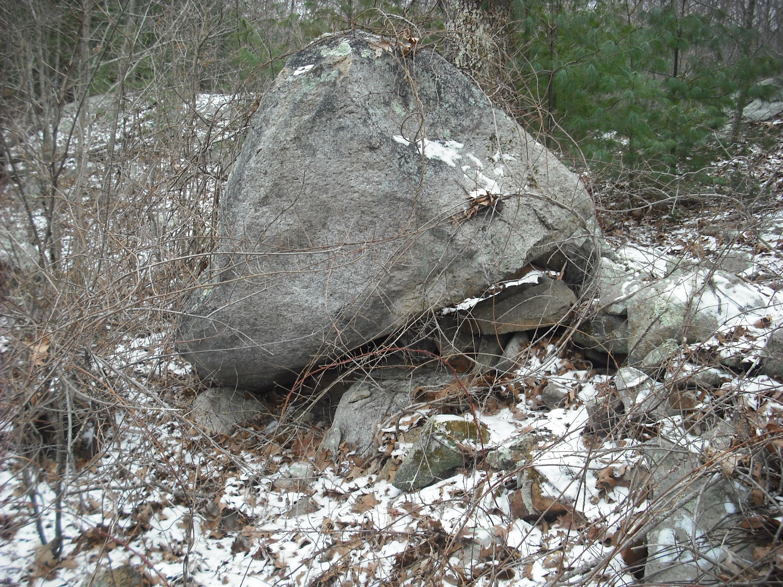
      Native Americans  may have also quarried boulders using different techniques.  Platform cairns are often seen in the woods, especially in areas with stone walls.  When I reviewed this photo, I noticed that the boulder had a flat, vertical front surface, and there is a sharp edge between the top and front side in front of the stacked rocks. No tool marks are visible.

The same is noted with this platform cairn.
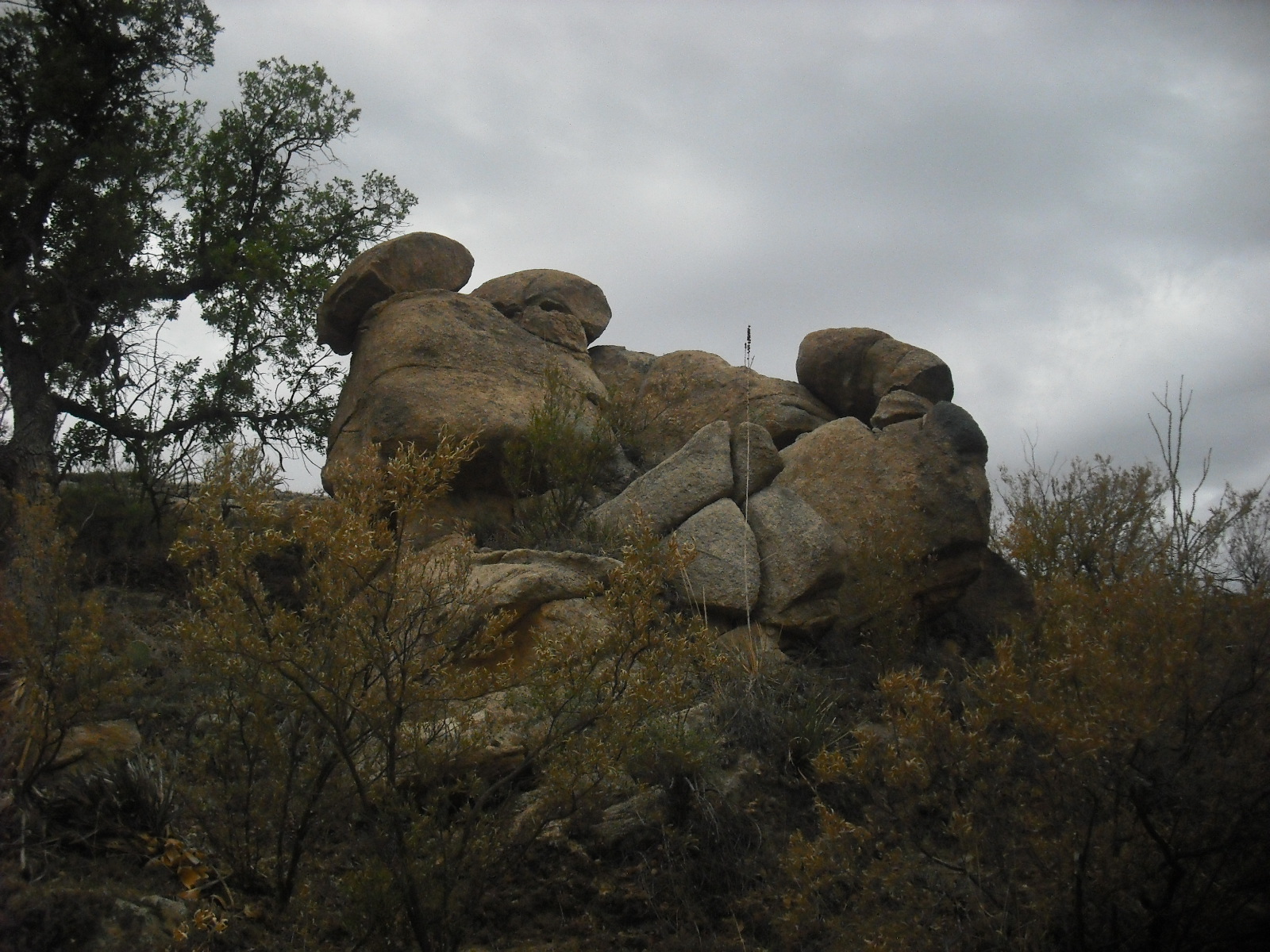
It is possible that Indians quarried away the front and top surfaces of these boulders, and then placed the resulting rocks on top.  The rocks have sharp angles and planes, suggesting they came from broken rock, instead of being picked up in the field.  There are farm walls close by, and visible in the background of the top photo.  Quarrying may also explain strangely shaped boulders, such as this cube in Westport, MA.
Perhaps Indians or some other persons hired by farmers broke up the boulders and built the walls with the resulting rock. This quarrying technique is less efficient than using metal tools.  The metal tools cut the rock completely to the ground, while a large piece of the boulder is left with the second method. Alternately, the creation of platform cairns may reflect a desire not to completely consume the boulders.
**********************************************************************************
Happy Samhain!

Wednesday, October 24, 2012

How to prop boulders


Here in the Northeast we often see  a massive propped boulder with lots of rocks under it.  It would have been an amazing engineering feat to lift this boulder and push a supporting rock under it.
I always assumed the small rocks were donations, but close examination shows squarish shapes and wide variation in size.  Notice how the lower surface of the boulder is flat, and that there is a sharply angled edge between it and the upper plane.

  Maybe the propped boulders were created by quarrying away rock from the base of a boulder, and then pushing in a supporting stone.  The stones visible under the boulder would be  fragments of the boulder.
     Here is one of my favorite propped boulders.  At this angle, it is easy to see how the rock was chipped away to create the "cave". The gouges on the lower surface are visible in the late afternoon sun.
The boulder below may have been a propped boulder in progress.  Note how there is a large horizontal crack in the bottom, as if chunks were to be removed.  This stone has the smooth, oblong  shape that propped boulders often have.

Propped boulders could also  be created by chipping away stone from a huge boulder leaning against an outcrop.

Here the lower face of a huge boulder has been chipped away, creating a straight edge and a small opening next to bedrock.  The stones have been piled next to it.  Someone may interpret this as donations next to a sacred place, another as quarrying in progress.
     The previous two pictures came from a hilltop containing several propped boulders, many platform cairns and farm walls. Some of the quarrying probably  produced stone to build the farm walls. I will show more of this site in a later  post.
     This hilltop site first attracted the natives with its huge boulders, some resting on bedrock.  Perhaps  the original purpose of native quarrying was to remove stone from boulders and create a "cave".  Unfortunately, the reason behind this laborious task is unknown.  The removed stone, along with other broken stone,  was stacked  into  cairns. Maybe the act of creating propped boulders and cairns was a form of sacrifice and devotion.  After the arrival of Europeans, native quarrying skills were put to use creating stone walls.
The  hilltop site guardian.

Sunday, October 21, 2012

Saint Kateri Tekakwitha

Today the 17the century Mohawk Kateri Tekakwitha is canonized  in the Roman Catholic Church. She is the first  Native American woman saint.  Kateri was the daughter of a Mohawk father and Algonquian Christian mother, and lived at Ossernenon, a hilltop village at what is now Auriesville, NY.   Ossernenon was also the site of the martyrdom of  St. Isaac Jogues 10 years before Kateri's birth.  When the chief forbade Christian prayer, Kateri lined up stones in the form of a rosary in the woods.  At the age of 20, she was baptized, and then fled to the mission village Kahnawake near Montreal.
This chapel stands at the site of Ossernenon, overlooking the Mohawk Valley. Kateri has a strong  following, especially among Catholic Native Americans. The photo below was taken at San Xavier del Bac mission church at the Tohono O'Odham reservation south of Tucson.
  This statue of Kateri  stands at a monastery in Maine.  There are always small stones left at the feet of this statue.


Wednesday, October 17, 2012

The Hill of Boulders

Here is a quarry which was used into the mid-20th century, and has many features suggesting  use by Indians.  The original quarrying of stone was from boulders on big hill.
Many of these boulders and those surrounding the hill are split and have metal tool marks, indicating quarrying in the early 1800s.
There is also an old pit-style quarry in this area.    The central  feature of this site seems to be the boulder standing  on top of the hill in the first photo.
This boulder rests on top of two others, with open space below.  Maybe this is natural, but it is quite impressive, especially since daylight may be seen  under the boulder from the bottom of the hill. This is how I noticed this structure.
    There are propped boulders on the slope.

Nearby are cairns and manitous, and also some interesting stone rows.
The first row is close to the hill, which is visible to the left.  It  has a loose structure, and some slabs placed lengthwise. 360  feet away is another wall, which contains a manitou with tool marks.  Evidently, someone else has been examining structures in this area, and has left plastic ties on the prominent ones.


This wall  has the same slanted slab construction as a wall I showed previously (10/7/11), but some of the stones have tool marks.
It continues about 400 feet, makes a right turn, continue another 140 feet, and then disappears into suburbia. It may have originally extended to a similar wall 1300 feet away on the other side of this development.
What is interesting about these long walls  is the Indian motifs constructed with quarried stone.  I suspect this wall was built as a property boundary for whites by  Indians.  Both walls shown above are perpendicular to the road, and parallel to each other, suggesting a house lot. There is a small family cemetery between them. I have noticed that these long, straight walls were built  between rocky hills and old meadows, perhaps as separations between Indian space and white farms.  It is also interesting that even if this wall was built after first contact, the slanted slab style was used.  It may be more stable on steep hills, and most of it is still standing.  However, this building style uses a great deal of material and labor.  Maybe one of the purposes of  boulder quarrying was to build long boundary walls, which the Indians did not need before the whites came.  Previously, Indians cleared  rocks from campsites and fields, and created stone rows 100 to 200 feet long.  An example of this would be the South Watuppa Pond stone rows.  Mavor & Dix wrote that  at least half of New England stone rows were constructed in the 16th and 17th centuries by Indians using metal tools.(p. 344). The stonework in  this overgrown quarry  is evocative of a time when two cultures were present in one area. There are hints that  Indian practices  persist:
 Manitous of  tool-cut stone

Young bent trees, the one above apparently made with wire.


Wednesday, October 10, 2012

Cairns on a hill

Here is a  hill crowned with interesting structures, that  I visited in the winter of  2010. 
On top of this hill is a foundation for a small building, which would have been surrounded by these structures.  This site is about 1000 feet south of  the  boulders aligned to winter solstice that I showed  12/22/2011. The bearing would  be about 155 degrees, but since  I don't know the vantage point for winter solstice, I can't be precise.
     Here are photos taken at this strange site on a cold winter afternoon.  Next to the trail uphill from the main road is this slab resting against a boulder, which  was produced by quarrying.
 
At the top of the trail stands this propped boulder on bedrock, pointing southwest.
Nearby are two boulders linked by a short chain of rocks.
There is still some debris and trash left over from the demolition of the house.  The house was up here until fairly recently, since it is marked on topo maps from the 1960s.  Small building foundations  are often present in areas with cairns and other structures. It is possible that  Indians remained in  these areas because of their significance, or they were marginalized to this rocky farmland.
     A wash tub rests in front of another  propped boulder.
 Here is a closer look at the propped boulder.  The tub is out of the picture.
There are many  platform cairns, and

 a massive pile of large rocks
There is a steep pile of boulders on the hill, which seems to be the focal point of the site. Perhaps it was once a landmark.
     Why would anyone pile rocks on top of a hill?
The short answer: they were already there, left by the glaciers.  These boulder-hills and rocky slopes are common in RI, and often have cairns, manitous, propped boulders and other structures nearby. So what is the purpose of the rock piles?
    Maybe there's a hint in the first picture, which indicates quarrying.  The rocks in these piles range from boulders to fist-sized.  The abundance of large  boulders made it an attractive quarrying site, and the rocks were sorted into different piles by size.  Here is a boulder that seems to be partially broken into relatively uniform pieces. There don't seem to be any tool marks, or the very straight edges typical of settler quarrying of boulders.
Some of these sites may have first been used as quarries by the Indians, and then by the settlers, who left some of the Indian features intact.  Perhaps the original purpose of the quarries was to produce stones with flat faces for stacking into cairns and stone rows. The labor in producing these stones could have been considered devotion or sacrifice.
     Here is a view of this hill from the west, before the area was overgrown. These hills crowned with boulders must have been an impressive sight in the late afternoon sun.  In the foreground, a propped boulder stands outside a wall.  The area at the foot of the hill is swamp.  The pile of boulders is to the far right on the crest of the hill, and another collection of massive boulders is left of center. The winter solstice site is barely visible between these two landmarks.


Wednesday, October 3, 2012

Catalina State Park

Last weekend was rainy, perfect for looking through old vacation pictures.  Here are  sunny photos from a 2011 trip to Catalina State Park, just north of Tucson, AZ. I decided to take the trail up to Romero Tanks, some natural reservoirs in the mountains.  Also, trails that head to water or food supplies often have interesting structures.
Heading up the trail to Romero Tanks, and looking back to Tucson.
Stopping in the shade near an outcrop, I see this human shape scratched into the dark area on this rock wall.
Maybe this is natural, but very symmetrical circle marks aren't common on rocks.  Along the trail I see  a propped boulder, with daylight showing underneath.  Instead of being placed on smaller rocks, the boulder seems to have its own "feet".

Here is an effigy made of stacked rocks, which resembles  a bird.
There are still  more strangely balanced rocks along the trail. After a long, hot climb, this is a welcome sight.
The tanks are quite popular with hikers. The water was ice-cold.
On the way back, I noted this impressive manitou-like structure.
Here it is, photographed from a different angle.  Just like in the northeast, this type of  fertility symbol is near water.
 Along the trail was this mysterious structure, which looks like someone was gouging out a shape from the boulder.  Perhaps a turtle?
At the base of the Catalina mountains is the ruin of a pueblo.  This is just a collection of fallen walls making the outlines of small rooms. Some of the rocks were later used to construct a small ranch house.
I wish I had a good picture, but this pueblo had a ball court with a crescent shaped berm, similar to those in Mexico, indicating shared culture among the tribes.