Wednesday, March 28, 2012

Miantonomi's Cave by Flashlight

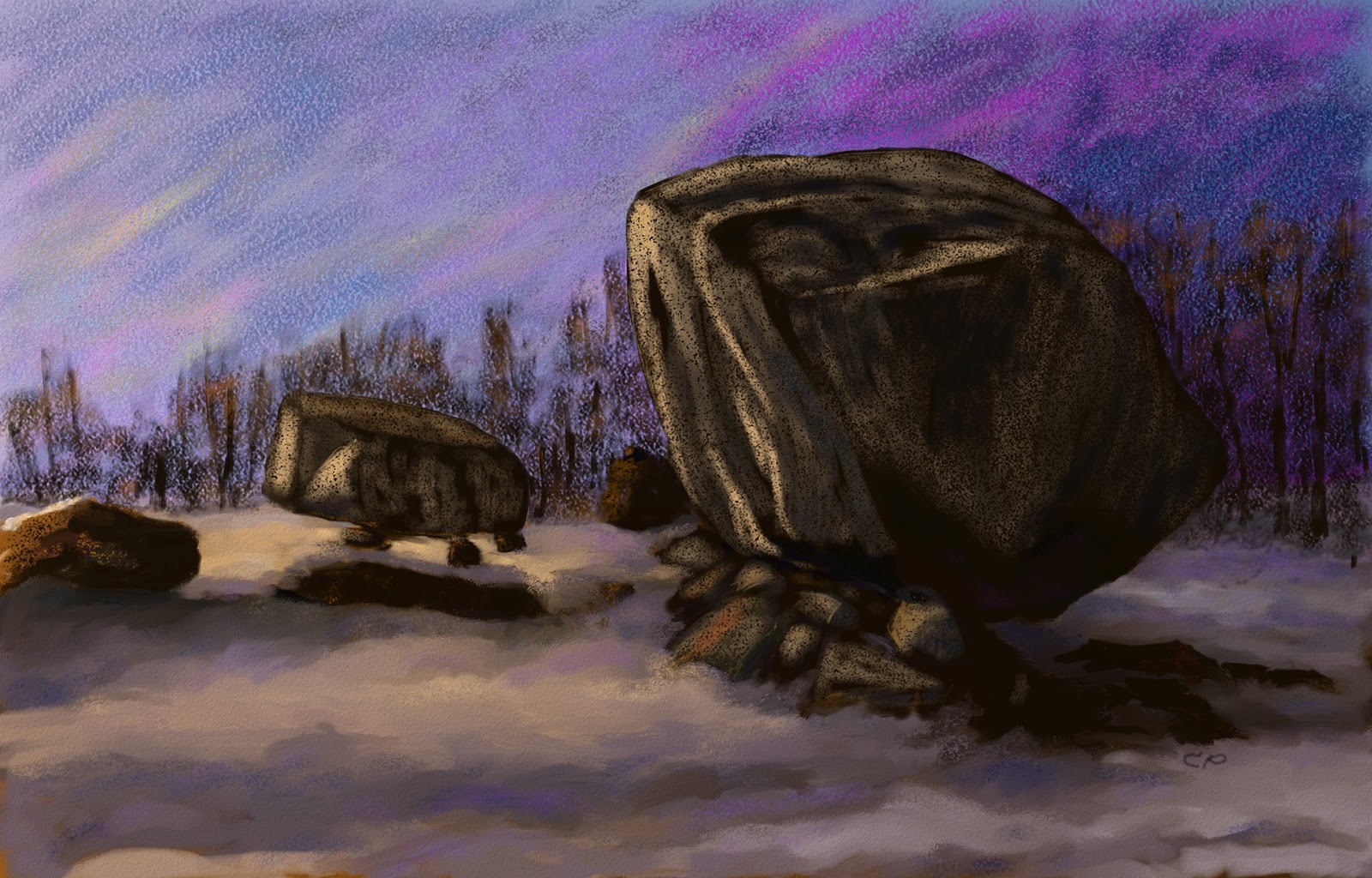
 On Tuesday, March 20  I returned to the site I dubbed Miantonomi's Cave, bringing along a strong flashlight, a compass, and a metal tape measure. This is a highly  simplified  plan of the site.

 The base rock is in blue, and the square boulder on top is in red.  The smaller boulder next to the square one is in green. I worked out the alignments by placing the flashlight in notches and grooves that seemed designed to channel sunlight, and photographing where the light fell.

Summer Solstice
The bottom edge of the square boulder has a 318 degree alignment.   Placing the flashlight along the edge produced a spot of light on a stone face directly behind the boulder. This would be the green boulder in the diagram. This face of the boulder slants at about 70 degrees relative to the base, so the light ray in the diagram appears to go under the boulder.

    The spot of light  was barely visible from on top of the structure, and did not enter the chamber.  I walked around the base, and found a small opening between the boulders to the left side of the chamber opening.  The light was clearly visible from this vantage point.  I had to stand on the small stone to see it, which may be its purpose.
The opening is in the dark area to the left of the chamber opening, between the two boulders. 

Equinox
Sitting in the seat in the chamber, I am facing  the small opening at 285 degrees.  I can see sunlight streaming under the leaning edge of the large boulder, right in front of me.  Perhaps this is the site for determining equinox sunsets. I wonder who sat here before me, and how long ago.

Winter Solstice
The south side of the structure's base west of the chamber opening is very smooth, and on a 253 degree bearing, with a wide and shallow notch visible in the center.  The other side curves away.  There may be some pattern of shadows on winter solstice, but  it is hard to tell.
Here is the  notch in the wall directly to the left of the cave opening, and a depression in the wall directly opposite.
Maybe the last rays of winter solstice sunset travel through the notch and light this depression.

August 13 or Green Corn Festival
 I noticed that the larger window had a notch in the bottom, presumably to channel the last rays of sunset light.  I placed my flashlight in the notch, and photographed the chamber. The bearing was about 305 degrees, corresponding to August 13.
The light fell on the point of the rock projecting from the wall.
This really was surprising.  If this structure is an observatory, it certainly is sophisticated. I have never seen this structure described anywhere in books or online, but someone may have seen it before. It would be intriguing to compare my findings to someone else's, especially if that person is an astronomer or archaeologist.  Undoubtedly this site has  more mysteries to examine.

Wednesday, March 21, 2012

Miantonomi's Cave

Sunday afternoon I was walking along a lake in northern Rhode Island.  I noticed these two large large boulders resting on a base with a narrow opening below the larger boulder.  The base is about eight  feet tall.  This is the south-facing side of this structure.
Walking up to it, I found a small chamber with two small openings under the roof formed by the huge boulder. The chamber is about 10 feet deep, 20 inches wide at the entrance, and  40 inches wide at the end. The boulder to the right seems to form a seat.
 Above this seat, rocks are jammed into the space between the base and roof boulders.
                                    
 One of these rocks projects forward and to the west from the wall. From the other side, it looks a little like an animal head.
This chamber has two "windows", a larger one with a small notch in the bottom, and
a smaller one.  The bottom edge of this window has been chipped away.  The large boulder on top of this structure partially blocks the light from this window, and is visible to the left.
Here is a view of the larger window from the outside, looking into the chamber.
The smaller window is hard to see from outside. This structure reminded me of King Philip's Cave in Sharon, MA.   For the sake of clarity, I nicknamed the site Miantonomi's Cave, after the Narragansett sachem. Maybe this chamber was also designed to mark astronomical events. This was suggested by examination of the large boulder on top of this structure.  It has a flat face to the north, and the long axis of this face has a 318 degree bearing, suggesting a summer solstice alignment. The edges look like the rock was chipped into this square shape.
There also are some small holes which appear to be man made in this and other boulders at this site.

They are about 1 inch deep and 1 1/2 to 2 inches in diameter. These seem to occur in patterns. Perhaps they are left from native rock splitting technique.
I returned Tuesday with a flashlight, and will show what I found in later posts.


Wednesday, March 14, 2012

Propped Boulders on a Hill

     On a hill somewhere in northern Rhode Island are massive boulders that have been propped either by nature, as they settled from glaciers, or by unknown hands. All of these propped boulders are impressive, but give no hints about their  purpose or  significance.
     The first propped boulder is this  one, about 10 feet  long, and  propped three feet off the ground.
Nearby is another propped boulder, which looks like a large section split off, leaving a straight edge.  In front  is a small collection of donation stones.
Further along and across the hill is a  third  massive propped boulder. There is a small bent tree in the foreground, and nothing under the boulder but some large rocks that look like manitous from this angle.
Finally, on top of the hill is a massive perched boulder with a striking wedge shape.
On the other side of this boulder is this pedestal boulder completely supported by stone feet. The afternoon sunlight streams under it.

This is the same one  Larry Harrop found a few  years ago.  These places aren't as unknown as you would like to think; someone has left a can of SlimFast on top of the pedestal boulder.  There's a bent tree marking this site.
 Oddly enough, I find the most interesting feature of this site to be not the pedestal boulder, but the large, wedge-shaped perched boulder.
Four years ago I did this pen and ink drawing of it. Large wedge-like boulders seem to be a common feature in hilltop sites. 
 
Here is a diagram of this hill, which is surrounded by wetlands.  The boulders are drawn larger than scale for clarity.
 The first three propped boulders are on a nearly straight line 365 feet long.  The pedestal boulder site is 357 feet from the third propped boulder.  It is quite a coincidence that on a hill covered with boulders, three large  boulders in a nearly straight line are propped. It is also interesting that the third propped boulder is nearly the same distance from the pedestal boulder and the first boulder. This suggests that there was some design as to which boulders were propped.
These mysterious boulders may make great art subjects, but it is hard to explain their purpose.  Maybe the space under the propped boulder was a portal to the spirit world, which would explain donation piles as offerings or mementos.  Or maybe tribal shamans obtained medicine from these boulders. Or maybe they were  shelters for natives on vision quests. The number of propped boulders in New England and beyond  suggests some important  function in native spirituality.
    

Wednesday, March 7, 2012

A Large Walled Area on a Hill

Somewhere in northern Rhode Island is a large  hill with a dirt road running  south along its crest.  A walk along this road doesn't reveal any interesting structures until this site appears. This site has two parallel wide walls joined by a thinner wall, forming a backwards "F".  The wide walls are about 3 feet wide, and  400 feet long, and the thinner wall is 550 feet long.  Here is  the wide wall on the north side of the site.
The two wide walls run to the southwest, and end at a cliff. The walls in this site do not connect with any other walls, and do not  seem to have any agricultural purpose. Here is a diagram showing the walls, with the cliffs to the west, and a slope with cairns to the east. The dirt road runs through the wide walls. The south  wide wall has a collapsed section.
                                              
 In a section of the north wall, near the northeast corner, the stones in the center have been removed, creating a small enclosure.
Inside the large walled area  are some low cairns.
Directly east of  the thinner wall is a large propped boulder on bedrock.
Following the slope downhill and to the east, I find many well-formed cairns, including one with an opening in its base. The opening faces to the east.  This might be a niche for offerings, or maybe it  represents a wigwam.
The orientation of the wide walls to the southwest suggests spiritual significance to Native Americans.  Perhaps this was a ceremonial or burial site.