Wednesday, November 23, 2011

Enclosure and Bird Effigies

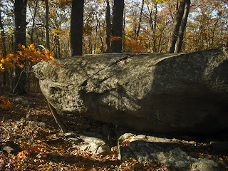
Somewhere in northern Rhode Island is a beautiful hill composed of jumbled  boulders.  On the shoulder of the hill is this boulder carved to resemble a  bird.
This photo was shown previously on Larry Harrop's blog.  The bird faces SSW towards a small, square enclosure built against a large boulder.  One wall of the enclosure continues about 100 feet away from the enclosure, until it ends at a hay field.
The enclosure is too small to be a building foundation.  Here is the whole enclosure, showing a small opening to the right.

What is the purpose of this enclosure?  The wall and nearby structures give a clue.  The wall is at a 253 degree bearing, suggesting a winter solstice alignment.  The enclosure may be a vantage point for observing astronomical events.   Unfortunately, if there were any other alignment markers, they were cleared from the field.  However, beyond the field and along the line corresponding to summer solstice is a large cairn field,
an outcrop,

and finally this huge bird head effigy.
 The presence of cairns and effigies at locations corresponding to alignments suggests annual ceremonies linked to these events.  I suspect that the use of small enclosures as vantage points in solstice observations was once widespread.  The reconstructed Pequot 1720 homestead at the Pequot Museum at Foxwoods shows a small, square enclosure that was found at Indian farm sites on the Mashantucket reservation.  The accompanying sign said its use was unknown.
     There are two hill top sites with astronomical alignments marked by large boulders in this northern RI area.  Perhaps these were used by the Indians before the arrival of  Europeans. After the Indians lost most of their land and moved to small farms, they may have built small enclosures and walls with alignments to continue their customs.  These inconspicuous structures would help keep these practices secret from their white neighbors.


Saturday, November 19, 2011

Moon Hill Revisited

Recently I visited Moon Hill to find more markers suggesting astronomical alignments.  While I didn't find any more  alignments, I did find more evidence the site has been used in the distant and recent past.
Here is a young bent tree pointing the way.
There were several cairns I never noticed before, including this one with a brick on top.
Here is the other side of the propped boulders on top of the hill.  That rotted tree was not there previously.
Donation or prank? There was also a rusty bucket nearby.  Finally, near the old building foundation I noticed this rock with a round cavity about 8 inches across.
A grinding stone from pre-contact times?  This suggests hundreds, if not thousands, of years of history in less than one acre.

Saturday, November 12, 2011

Beyond the Picnic Tables

Here we are at the same site in the previous (11/7/2011) post.  More leaves have fallen, and the stronger light and shadow bring out more detail. After some wandering, we have returned to the wall.
The wall runs downhill, crossing  a boulder.
Near the wall we notice a large propped boulder.
Close examination shows many donation stones under the propped boulder.

On the other side of the wall is a large boulder leaning against an outcrop and forming a cave. The cave faces east.  There is some stone work outside the cave.
The donations under the propped boulder suggest this site has  spiritual or historic significance.

Monday, November 7, 2011

Hidden in Plain Sight

Believe it or not, these pictures were taken at one of Rhode Island's most popular picnic locations.  Away from the roads and picnic tables  is  a wonderful landscape of massive outcrops, propped boulders, and stone rows.  Let's go for a walk through this mysterious landscape.
     On top of a hill overlooking a lake, two massive boulders stand on bedrock, nearly touching each other.  They were once a huge boulder that split in half.  Careful examination of the faces shows they would fit together.  Unfortunately, today they are desecrated with graffiti, so I have substituted a white-on-black chalk drawing.
Here are the supporting stones of  the boulder to the left.
Near this site is a cluster of huge boulders, some of them propped.
Heading down the hill to a peninsula in the lake, we find a large manitou,
and a massive split boulder that dominates the site. Despite the snack wrappers and discarded fishing gear, an air of serenity  pervades the peninsula
Heading uphill and past the twin boulders, we climb up a steep hill and find this perched boulder.
There are some strange, gouged-out areas  at one end of this boulder.
Beyond this boulder is a huge propped boulder with a smaller one in front.
Crossing the top of the hill, we find outcrops and stone rows, and decide we must return later to trace their routes.
Time to go home...


Sunday, November 6, 2011

Hipses Rock Revealed

On Saturday, November 5, the  Neutaconkanut Hill Conservancy had a walk to Hipses Rock.  The rock is on private property, and the owner generously cleared a trail to the rock and joined in the walk.  Ranger John McNiff gave an informative and entertaining talk on the history of Hipses Rock.

The east facing side of Hipses Rock, with the "caves" visible.  Originally, there was one large cave, until  the large piece to the left broke off about 100 years ago.  Could the cave have been a chamber for viewing astronomical alignments on Neutaconkanut Hill?  Perhaps.  Little stonework is left at the site, but I did note these donations in front of the cave.
Helen commented that there is a memorial pile on the site.  I did photograph this stone pile behind a wall, but  was  not sure if this is a donation pile or a rock pile created by land clearing.

Hipsis Rock is composed of  sedimentary rock with this rough texture. The other rocks around it are granite.
It was dropped here by a glacier, and was a prominent landmark for time immemorial.


Thursday, November 3, 2011

The Bent Tree

     Stone structures in Rhode Island often are marked with bent trees.  Most of these bent trees  are large and over 100 years old, but  many are much younger. This continuing custom of tree-bending  was mentioned by Mavor & Dix.    I always note and photograph bent trees, and  have found that they fall into two general categories.
     1.  Bent trees formed with rocks.
The rocks are placed on a sapling, and it grows to form an L-shape.  Here is a young tree on an outcrop with a propped boulder. The stones are still in place.
Here is an adult bent tree, pointing towards  a stream.
 Granted, some of these trees may have been formed naturally when another tree fell on them.  However, the presence of these trees at structures or along trails suggests they  were formed deliberately.
2. Bent trees formed with thongs.
This type is common  in former Cherokee lands, where they are called "trail trees" or "thong trees".  The sapling is bent over and tethered to the ground with a thong or wire.  Here are a couple of examples.
Some of these trees may be bent with a cross bar as well as a thong.
 One important point in this photo is that the bent tree is near a road.  Generally, I find that the smaller, younger bent trees are near well-worn trails and prominent structures such as large propped boulders.  Structures in remote areas often  have only large, older trees.  This suggests that the people who are bending the trees have some understanding of the significance of the structures, but do not remember the locations of all of them.
     One of my favorite bent trees is this one, at the edge of a cliff overlooking a swamp.
It appears to point to this magnificent stone stack at the base of the cliff.
About 1000 feet west of this cliff is a small hill surmounted by a large boulder.
This boulder also has a bent tree.  Glimpses of this boulder may be seen from the cliff in the winter.  This area used to be a farm, and the swamp was once a marshy meadow.  It may have looked like this on a September afternoon.