Wednesday, October 30, 2013

Circling the Hilltop

There are still more propped boulders in the hilltop site I showed last week (10/23/2013), and they form  a loose border around the hill.


     Some of the boulders at this site are close to the road and in full sight in the winter.  By now, any Rhode Islander reading this blog knows where this is!
    Waypoint 1918


It looks like some of the side of this boulder was carved off to give it this squarish shape.
Waypoint 1924, an impressive boulder standing on outcrop.


Waypoint 1925, a perched boulder on an outcrop.


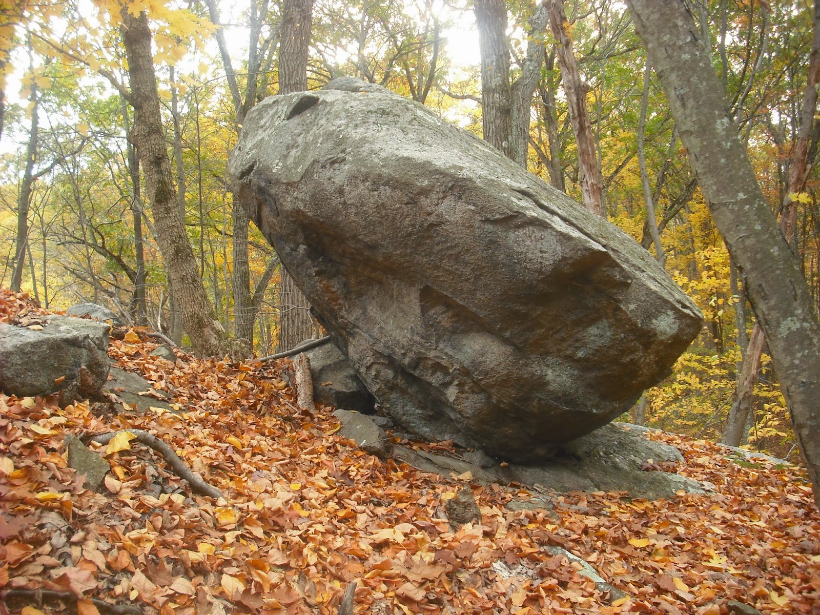
Waypoint 2296, the same propped boulder shown last week. 


Waypoint 1865, a large boulder. Stone has been removed from the lower edge of the boulder to the right.


Waypoint 1932, which was  shown previously (11/7/2011,10/24/2012).


This has many stones underneath, which may have been produced by stone being chipped away to produce the propped shape.


Waypoint 1907, a rather  unusual shape suggesting a split boulder.  I didn't include it in the circle because it was probably  produced by quarrying.


     Previous posts on this blog have shown  groups of  quarried  boulders with prominent tool marks  near stone walls (10/31/2012). Sometimes I wonder if propped boulders were also produced by settlers quarrying  rocks for construction purposes.  This is not likely  because the propped boulders are usually single and  not near stone walls.     The occasional propped boulder has what looks like some quarrying or removal of slabs, but most look like they were carved into propped boulders and left as the finished product.  The purpose of carving these boulders, whether to mark villages or ceremonial sites, or  as memorials or art, remains a mystery.
     
*****************************************************************************
Forget what you learned in grade school about Asians crossing the Bering land bridge to people the Americas. The real story is more complex, as described in this short article from The Scientist, here.


The Alaskan Cemetery

Check this out!

Wednesday, October 23, 2013

Return to the Hilltop

Last weekend I took advantage of the pleasant weather to return to the hilltop I showed on 9/4/2013.  I looked more closely at the propped boulders, to see if there were any marks, and to determine if there were any particular orientations of these boulders. Here's what I found:

      Waypoint 1873.
This is  a large propped boulder with a smaller propped boulder in front.  From the other side, it looks like the boulder is pointing. The long axis of the larger rock was almost perfect N-S.


     This large  boulder has a prominent squarish  mark that looks man-made on its west face. It is about eight inches tall. Immediately to the right of the hole in the bottom of the square mark is a large quartz crystal (arrow).  The deep marks may have been created by someone gouging out quartz.


 The bottom part of this mark  is visible above and  behind the smaller propped boulder.

.

     Waypoint 1830


This boulder, seen from the side opposite that shown 9/4/2013, also had N-S alignment of the long axis.  The open space underneath has E-W orientation.  Closer examination shows flat rocks that might have been pulled out from underneath the boulder when the open space was created.


On all these boulders, the long axis orientation was N-S.  Since many of the other boulders on this hill have this orientation,  the glaciers may have deposited them this way. 
     The propped boulders in the alignment (9/4/2013) definitely show some human working, especially this one at waypoint 1870.


 The planes remaining when rock was removed are visible on the lower surface. Maybe the granite at the bottom of a boulder in contact with bedrock gets cracked  from repeated exposure to freezing and thawing.  The Natives found it  easier to chip the granite from the bottom of the boulder, creating a propped effect.
     
     Whenever I think I've seen everything in a site, something proves me wrong.  I was wandering down the side of the hill on an unfamiliar path, and I saw this:


Closer examination shows it is a beautiful propped boulder, with the inverted triangle shape sometimes seen at this site.


Here's a view of the other side. The long axis was also N-S.


I imagine this area once looked like a sculpture garden when the Natives kept the forest thin.  It is hard to believe that these structures were in full view for the centuries during which the area was farmed, and nobody noticed them.


Wednesday, October 16, 2013

Walking Up Neutaconkanut Hill

 A few years ago, I went for a walk up the heavily wooded west slope of Neutaconkanut Hill. This hill was one of the original boundaries of the territory ceded to Roger Williams by Canonicus and Miantonomi.  Over the years, the hill has been used as a farm, quarries, illegal dump, stolen car dismantling point, park with ski slope, and now as woodland walking trails. After all these uses, a few suggestions of Native use remain.
     Walking up from the bottom of the west slope, I reach a large outcrop.


 These large, square blocks suggest that this stone was once quarried.  About 265 feet further up the slope is this propped boulder.  It has the usual oblong shape of propped boulders in RI.


 The next structure is this small perched boulder, about 86 feet  further up the slope.


That is a satellite dish in the background.  The  outcrop and two structures make a straight line leading to the summit of the hill.  If there were other elements in this line, they are long gone.
     There are two more propped boulders on top of the hill.  These are 350 feet apart, and it is impossible to tell  if they were once part of a larger arrangement.


Both have remained because they are in nobody's way, and are resting on bedrock.  Canonicus Rock was not as fortunate, and was reduced to a pile of rubble in the 1950s as a precaution against it falling into Plainfield Street.


Wednesday, October 9, 2013

An Old Quarry in Autumn

      This week I'll take a break from the propped boulders and show some lovely fall pictures of an interesting site in northern Rhode Island.
     One of the stories I grew up with was that farm walls were built by the farmers using stones from the field.  These stones were uncovered by plowing, and seemed to rise to the top of the soil due to repeated freezing and thawing.  One problem with this story is that the rocks in a field would have very variable sizes and shapes, and many would be rounded due to the action of the glaciers and erosion.  It would be difficult to build a wall with only odd-shaped stones. Many of the walls were built with quarried stone.
     Somewhere by the Pocasset River, stands an outcrop that has been quarried.  The foliated granite in this area breaks easily into squarish pieces and slabs.


Rocks of varying sizes are sorted into piles around its base.


Squarish pieces seem to tumble down the slope.


Near the base of the quarry, a chunk of quartz twinkles through the fall leaves.


These rounded rocks were removed from the banks of the Pocasset and piled separately.


The squarish rocks were used to build this wall standing 50 feet away. The walls are compactly built, and still standing. 


Wednesday, October 2, 2013

Landscape with Propped Boulders, Part 2

Last week I posted a hilltop  alignment of propped boulders that seemed to form part of an enclosure.  This week I will show the long east-west line on the south side of the enclosure.  The red dots are cairns, and  the yellow dots joined by yellow dashed lines are the propped boulders in the enclosure. The blue dots with blue lines are walls.


Starting from west to east, the first waypoint is 599,   this impressive propped boulder that was shown 4/24/2013.


The next propped boulder is at waypoint 598.


The line continues west past some prominent boulders.  Some may be natural, and  I have included them because their striking appearances lend them to use as landmarks.  Perhaps boulders were propped as markers where there were no distinctive natural boulders.
Waypoint 636


Waypoint  637. This boulder looks like it has been chipped away underneath.


Waypoint  638.  A boulder broken into large fragments, with stones placed inside the splits. Since the stone in this area splits easily, it is hard to determine when this occurred.


Waypoint  462.  This massive boulder is cleanly split in half, with no tool marks. This may be a natural split.


The line ends at the structure at waypoint 457, shown last week.
      Propped boulders may have been boundaries of old Native campsites, villages, or fields.  Maybe these old borders  were used in land transfers to settlers. The original boundary of this old farm was close to the line of boulders.  Some bloggers have described stonerows that zig-zag from one boulder to another.    If the boulders  were used as boundaries in land transfers, the farmers may have walled in the spaces between the boulders. I have never seen this in northern RI.  However, at this site, it is noticeable how close propped boulders are to farm walls.  The boulder at  waypoint 599 is directly in front of a farm wall.  This boulder, further to the north, is also in front of the long wall that separates this site from other properties.


So is this one, 100 feet further to the north.


Those holes were drilled by a farmer to blow this boulder up.  Evidently, this didn't work out!