Wednesday, February 27, 2013

Parker Woodland

    Recently my mailbox yielded a surprising piece of  mail.  The Winter 2013 issue of  the Audubon Society of RI  Report has an article about the history of Parker Woodland, by Jim Gass.  This is the ASRI 860-acre  wildlife refuge in Foster and Coventry, RI, and the site of the tall, conical cairns and other mysterious stone structures.  Unfortunately, the Report is not posted online, so I will quote from the article and add my own photos of the sites described.

     "Moving east along the Paul Cook Trail you will come upon one of the well-known attractions at Parker Woodland, the stone cairns.  These are cone-shaped piles of stones that have been carefully crafted by human hands.  There are dozens of these structures at Parker, and no one is quite sure how old they are or who built them.  Colonial farmers often made piles of stones when they were clearing fields for plowing.  Sometimes farmers would make piles of stones and sell them like cordwood.  Also, both the Narragansetts and Wampanoags have stated that the cairns found in Rhode Island and Massachusetts were built by their ancestors for ceremonial purposes. The fact that the cairns at Parker are very carefully constructed seems to point to Native American origins, but this has not been confirmed".


This is somewhat of a departure from the sign posted at the site, which was described in my post of  2/8/2012.

     "Along this trail (the Milton A. Gowdy Memorial) are two colonial-era rock quarries and Table Rock, a structure that is believed to have been used by Native Americans to communicate over long distances".


The article does not mention how Table Rock was used, but presumably it was struck to produce sound.  The crystalline structure of some  granite allows it to vibrate when struck.  Some rocks, such as Bell Rock in Fall River, MA, are reputed to make loud sounds.

     "Also near Table Rock is a foundation of a house that has small cubby holes.  According to Laura Carberry, 'they appear to be storage areas attached to the outside of the foundation, the largest being about as big as a sheep or adult person could fit into, then they become as small as a jar.  I think perhaps they were used for storage or for shelters for animals'".

     Here as an overview of the cubbyholes at the foundation.


The largest cubbyhole has fallen in.


Light through the back of the smallest cubby hole indicates it is not part of the building foundation. I might speculate that these were used for firewood and kindling, keeping them close to the house and out of the weather.


     This is the doorstep of the house.  Imagine how many generations of feet have crossed it.
"Returning to the Paul Cook Trail, you will eventually come to the remains of the Vaughn family farm.  The Vaughns came to Coventry in 1750 and their farmland was comprised of fields, pastures, and woodlots."


This  farm is also surrounded by cairns, which presumably were from field clearing and quarrying for stone walls. Some may have been left behind by natives.

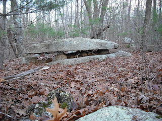
    If you are within driving distance of RI, this is a great place to visit and see plenty of cairns, walls, propped boulders, and other structures right from the trails.  The directions and trail map are online at asri.org.

Sunday, February 24, 2013

The Esker

    Eskers were formed  by streams that ran through glaciers and deposited sand and rubble in their beds.  After the glacier melted, the esker remained as a long, narrow ridge similar to a rail bed on the landscape.


Here a stream has worked a channel through a glacier, leaving a column standing next to the rest of the original wall.  The back wall is carved out at its base by the running water.  The walls and column  show layers created by  years of snow deposition. This is all visible because the flow of water is low now.

Wednesday, February 20, 2013

Trail of Effigies

Are you tired of the snow, slush, cold, and biting wind?  Do you need a vacation, but are low on money and time off from work?  Take a virtual hike at Joshua Tree National Park, using these photos taken in May 2010. No sunblock needed!
     Starting point is Cottonwood Springs.
There isn't any surface water visible, but there is enough seeping water to support these trees.  This water supported the Cahuilla tribe for centuries.  In a clearing beyond the trees stands this split boulder with deeply worn mortars.
The Cahuilla didn't live among the palm trees, because they are very flammable.  They lived in thatched huts and came here daily for water and did their chores here. The surrounding landscape is a jumble of boulders which eroded from the heavily fissured monzogranite bedrock.  Generally, smaller boulders rest on larger ones.

 However, we see some boulders suggesting alteration by humans, such as this propped boulder.
Here it looks like someone worked away the top of the lower boulder, leaving small supports for the upper boulder.  Close by is what looks like an effigy of a snake.
The "smile" continues to the other side.  In native mythology, the snake was the guardian of springs and water. This picture always reminds me of the plumed serpent carvings of Mesoamerica.   Undoubtedly there was a great deal of cultural exchange, as petroglyphs of macaws and horned snakes are common in the Southwest. There are no petroglyphs here since the granite is not suitable for artwork.
     This massive split boulder stands across from the snake effigy.
There aren't many split boulders at Joshua Tree.
After a little more hiking, we notice this strange outcrop on the left.
It looks like a horse, but the Cahuilla didn't have horses.  Perhaps it was a deer or other animal. Even if it is just a natural formation, there is something deliberate about it, especially with the stone placed on top of the head. A little further is this strange comma-shaped stone atop an outcrop. This shape appears again later along the trail
This boulder was stacked deliberately.
It's a  larger rock on a narrower base, and turned at an angle. Further along the trail, another propped boulder.
I see disk-shaped "feet", suggesting the  rock was carved.
Finally the trail reaches a small hill above a wash.  A massive structure overlooks the wash, the left boulder having the same comma shape as the smaller stone seen previously. These unusual shapes suggest the boulders were sculpted.
Maybe this is supposed to look like two animals mating, or be a doorway.
Nearby is what looks like the Cahuilla version of a manitou.
If this rock split naturally, where is the other half?  There are no obvious carvings on the face.
This seems to be the end of the effigies, and time for a leisurely, if rather hot, walk back to Cottonwood Springs through some bold scenery.


Saturday, February 16, 2013

The Glacial Erratic

Another weekend with snow and slush!  Time for another trip to the last ice age through imagination and artwork.
It is nearly sunset 17,000 years ago at what is now South Watuppa Pond.  The face of this glacier catches some of the light of the late afternoon sun, while light plays through the large calved glacier fragment to the left.  Almost hidden in this scene is a large puddingstone that has been dragged all the way from Dighton.  Many centuries later, this puddingstone will be the end stone in  the stone row of a native campsite.

Wednesday, February 13, 2013

Geology of Manitous

Recently I read a "Roadside Geology" book about RI and CT.   There are two huge masses of granite under RI, Esmond and Scituate granite. This granite is foliated, forming outcrops of layered stone that weathers and breaks off in flat pieces.
 Here is a massive outcrop of  Scituate granite.


Here are the foliations of this rock

Some of this stone was used to build a slanted slab wall that is nearby.
These slabs are about three inches thick, and are relatively uniform.  However, occasionally very thin slabs were produced.  These were not used in wall construction, but were often left standing.
The small slab resting against the tree is less than an inch thick.  The larger manitou is about 2 1/2 inches thick at its base, and less than an inch at its peak.
Sometimes these thin slabs were left at the edges of the outcrop used for quarrying. The one in the center is about an inch thick.  Since granite weighs about 150 pounds per cubic inch, a three-foot by two-foot manitou only one inch thick would weigh about 75 pounds.
Therefore, they could be set up some distance from the outcrop where they originated. Here is the same group I showed on 1/2/2013, seen from the side. Since these are standing near the top of a very steep slope and overlooking the slanted stone row,  it is safe to conclude these were placed here deliberately and permanently.
Although the slabs are almost three feet tall, they are very thin and heavily eroded. The smaller one in the background  is also less than an inch thick.
Some of the slabs seem to be nearly completely split from each other, probably by water freezing between the layers.  The slabs in the  stone rows may have been  slanted to prevent water from freezing between the layers and splitting the stone. The amount of erosion on this granite suggests these manitous have been standing in place for hundreds of years.  How can one estimate the rate of  erosion? By comparison to the   dated stones left to erode in cemeteries.
     Here's a gravestone made of foliated granite in a local farm cemetery. It is also extensively split. This type of granite was not used often in grave markers, probably for this reason.
There is no date, but the nearest stones with dates indicate this one dates to the 1700s.  It is not as deeply split as the manitous.

With more examples for comparison, it may be possible to estimate how long these eroded manitous have been standing in place.
     Many of the standing  slabs and manitous I have photographed over the years are thicker than these, often up to 6 inches.  I will write about them in a later post.  Maybe there once were many more  thin manitous, but they have slowly eroded and broken.


Sunday, February 10, 2013

Snowbound

I always liked this view of the rocky slope  at Snake Den State Park, especially because of the oddly tilted boulder to the right. This massive pile of boulders was left here by a glacier over 17,000 years ago.  Having some spare time due to the blizzard, I used the tilted boulder in a painting of the glacier slowly melting.

Wednesday, February 6, 2013

On a hill

This hilltop site is across the pond from Miantonomi's Cave, and is a mix of native and farm stone structures. At the top of the hill is a  row of large  round stones, that transitions into a typical farm wall.

The farm wall.
The large stones are rounded, suggesting they were left on the hill by glaciers. Maybe these were originally cleared by natives for a campsite or field. The farm section has smaller, more squarish stones that may have come from quarrying of local boulders and outcrops.  On top of the hill is this strange structure:
On the other side, the rock faces close to the crack show that someone was chipping away rock to make some sort of pedestal structure.   Hidden next to a smaller rock is this old enamelware coffee pot.
Of all the things to find near stone structures, it is usually a metal bucket, pail, pot, or other container. If this was just storage of camping supplies or dumping trash, there would be other articles around.