Hidden behind trees, fences, and ranch houses in Johnston stands Hipses Rock, a large glacial erratic boulder with a long history. Hipses Rock was mentioned, along with Neutaconkanut Hill, as one of the boundaries in the land transfer from the Narragansetts to Roger Williams. It used to be surrounded by farmland, and local children would play in the "caves" in its base. Powwows were held at the rock in the 1930s.
Unfortunately, now Hipses Rock may be seen only in glimpses in the winter. A grainy old photograph was the source for this ink painting.
Up on a ledge west of Atwood Avenue stands a huge, squarish boulder. It is quite prominent against the sky in the winter.
Due to its location on private property, it is hard to photograph. There really is a small "peak" on top.
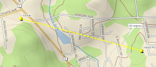
When I was looking at my topo map of the area, I realized that this boulder was on a 285 degree bearing from Hipses Rock, suggesting it was a marker for spring and fall equinox sunset.
There is also a 73 degree alignment between Hipses Rock and a stone row on Neutaconkanut Hill. This may correspond to summer solstice sunrise.
And here is the stone row which runs across Neutaconkanut Hill at a 73 degree bearing. That's a satellite dish in the distance.
If there were any other alignment markers, they are long gone. Perhaps Roger Williams knew the significance of Hipses Rock to the Narragansetts in marking astronomical events when he wrote the following. "The Sunne and Moone, and Starres, and seasons of the yeere doe preach a God to all sonnes of Men, that they which know no letters, doe yet read an eternall Power and Godhead in these."


No comments:
Post a Comment