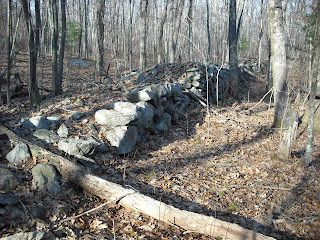
The two wide walls run to the southwest, and end at a cliff. The walls in this site do not connect with any other walls, and do not seem to have any agricultural purpose. Here is a diagram showing the walls, with the cliffs to the west, and a slope with cairns to the east. The dirt road runs through the wide walls. The south wide wall has a collapsed section.

In a section of the north wall, near the northeast corner, the stones in the center have been removed, creating a small enclosure.
Inside the large walled area are some low cairns.
Directly east of the thinner wall is a large propped boulder on bedrock.
Following the slope downhill and to the east, I find many well-formed cairns, including one with an opening in its base. The opening faces to the east. This might be a niche for offerings, or maybe it represents a wigwam.
The orientation of the wide walls to the southwest suggests spiritual significance to Native Americans. Perhaps this was a ceremonial or burial site.


This comment has been removed by the author.
ReplyDeleteYour presentation is amazing. I wish I could convey sites so well, and draw such great pictures.
ReplyDeleteAlso, I want to comment that the "low cairns" look to have had a hollow interior. That is consistent with burial.
ReplyDeleteThere are some other local examples of wall enclosed Native American burials. Low profile
ReplyDeletecairns have been suggested to be more recent than taller ones in order to avoid detection, but a walled in area would seem to work against that purpose.
Regarding walls, I've wondered whether part of the purpose at ceremonial sites is to designate an care to be kept clear to allow a proper view, but that might not be true for this example.
'an area' to be kept clear.
ReplyDelete