Wednesday, March 27, 2013

Modification of Native Stone Rows

     Recently I went on a walk on the dirt road though an old farm  in a state park.  The first sight after an open  field is this old barn foundation. These were often built into hill sides, with only one exposed foundation wall.

 
The other side has a jumble of stones, which was probably the side wall
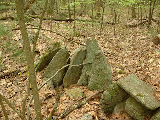
Just beyond this barn foundation is a  row of slanted slabs, some with V-notches.  This is the same row found by Larry Harrop.
     The stones are about three feet tall, two feet wide, and 6 inches thick.  Assuming granite weighs 150 lbs per cubic foot and the buried part of the slab is one foot long, the weight would be 600 lbs. Evidently, moving these slabs anywhere would require great work.
     Close by is this outcrop.  The face shows layers that are equivalent to the thickness of the slabs, so the slabs were probably broken from it. This stone row design is so unusual, it is probably safe to conclude it was built by Native Americans.
  Here is a clearer photo of the stone row, taken five years ago.
     Some of these stones have notches at the top, such as the one near the center in the photo. 
     Further along, the stone row changes to a low wall and finally ends in a low area.  The total length is about 400 feet.
.
 To the west  is a second wall about 600 feet long, containing some more  standing slabs with notches.


This one has  a clear cut notch.
     These walls surround an area that was once a  meadow.  Here is the map, with the barn foundation marked at lower left,  along with  the first and second standing stone rows as dark blue lines A and B, respectively. Gaps in the walls may have been filled in with wooden fences, or  piled stumps.

     The standing stone rows were  built by natives, and a farmer added to them to make a meadow wall.  The barn was built there to take advantage of the stone rows. Although many stone walls look too low to have contained cattle and sheep, they originally had wooden railings for this purpose.  Fencing laws from the 18th and 19th centuries required walls to be at least 4 feet high, and this was enforced by the town fence viewer, who had the power to levy fines.  The notches in the stone slabs could have been added by the farmer to hold the railings in place.  
     Here is one possibility for adding railings.
 

.


Sunday, March 24, 2013

Hale Reservation 2003

Taken at Hale Reservation in April 2003
That sure looks like a manitou standing in the stream pouring from the  Storrow Pond dam.

Wednesday, March 20, 2013

Winter Solstice, Lunar Standstill

Here I am, out for a walk in the area containing the winter solstice marker in the previous post (3/13/2013).
 This boulder is about 7 feet tall, and propped on rocks shaped to hold it in place.
Nearby is a lower boulder with a rock on top.
Heading along the trail that runs past this boulder, I see a promising sight:
This looks like a trail marker, and to me it says, "Look here".  A short distance, and I find a rusty bucket, all by itself.
Even better.  A few more steps reveal the following, surrounding a bare patch of bedrock about 10 feet across.
This oddly shaped boulder suggests a bird profile (red lines) or a human face (yellow lines).  Or maybe it is supposed to be both, similar to Indian artwork from the Pacific Northwest.
This small site is about 480 feet from the propped boulder, and at a 245 degree bearing.   The site is at waypoint  1738, and the winter solstice boulder is at 1680.  The red dot 1733 is the boulder topped with a large rock.
The 245 degree bearing from the site to the marker  suggests lunar standstill.  The U-shaped arrangement of four rocks faces the marker, and may provide a vantage point for observing alignments. Or maybe it's all a coincidence.  In any case, it was the inspiration for this rather wild painting.
Who has visited this site, and why?


Wednesday, March 13, 2013

An Observatory

In March 2011, I was walking up a utility access road, and I looked up and saw a huge propped boulder on the ridge overlooking the road.
This boulder looks like a chamber and  faces west.  The smooth vertical plane in the front above the smaller stones suggests some of the boulder was chipped away to form this chamber. Here's a somewhat burned-out close-up.

Some more exploration revealed the following:
At  about 1300 feet on a 318 degree bearing, are first this massive boulder, then an outcrop with propped boulders.  The outcrop has the bent tree with  rocks still piled on the trunk,  which was shown on 11/3/11. This site would correspond to summer solstice and Pleides set, according to the very useful "Stupid Sheet" from  Rockpiles.blogspot.

1900 feet away from the chamber boulder and at bearing 335 degrees is a large propped boulder on an outcrop, complete with a bent tree.  Notice the pointed shape. This boulder does not  correspond an astronomical alignment from the chamber, but could be  a marker for a different vantage point.
2000 feet from the chamber boulder and at bearing 285 is a large outcrop topped with a  pile of small rocks, and surrounded with cairns.  This  site also contains the ruins of an abandoned farm, and is so interesting, it deserves its own blog post.

The west face of the outcrop.
Finally,  across a lake and on a hill 3300 feet away from the boulder chamber stands this 7-foot tall propped boulder. It is the only large boulder on the hill, and has a somewhat pointed shape, like the one above.

The supporting stones are shaped to hold this boulder.  The 253 degree bearing suggests it is a marker for winter solstice.   What is most interesting about this possible observatory is the propped boulders and cairns at the marker sites.    Here is a diagram.


Painting the view from the boulder chamber is impractical, since the markers would appear tiny, especially in artwork viewed on computer monitors and other digital devices.
     One thing that has always impressed me is how many alignments appear in northern RI.  Some are probably coincidence, but others look deliberate, especially when the markers are large propped boulders.  This site is actually within reasonable hiking distance from some others I have shown, so the question is why so many, and to what purpose?  One can see the difficulties involved in using these aligned boulders for accurate solstice readings:  the observer would be looking at a distant marker against a blinding sun.  Perhaps they were used for observations of the Pleiades and other constellations, and had some ceremonial use. They may have been a way to organize the landscape in respect to the seasons.


Wednesday, March 6, 2013

Cave with Manitou

Saturday I went hiking at a conservation area in Smithfield,  RI.  This area was once a farm, and the trail went up a steep hill past a large outcrop with a shallow cave.
There are no visible marks on the cave walls. The cave faces east, and this is the view.
There is water further downhill. And this is what I saw right next to the cave.
A manitou about 6 inches thick standing at a slant,
and what looks like a niche.
There is something familiar about a cave with a manitou, and I remembered the shrine described by Norm Muller on Larry Harrop's June 23,2011 blog posting here. There aren't any stones inside the cave and the  floor is stirred up, as if kids were playing there.  However, the manitou and niche suggest Native spiritual or practical significance.
     The cave faces east, and could have been used to observe solstice sunrises or Pleiades rises.  Both summer solstice and equinox sunrises would have appeared over the crests of nearby hills. 
     In this same area are two other  manitous. This one is 100 feet  away to the northeast, also on a hill above a tumbling brook. The late afternoon sun shows it faces to the southwest.
And this one is about one mile away to the northeast, on a hill near a river.
None of these seem to have astronomical alignments.  Both of these sites were cleared for farming, so any other structures would have been removed.  I have looked at hundreds of pictures of agricultural structures such as pens, sheds, smokehouses and outhouses, and none of them would have incorporated these slabs. My best suggestion is that these manitous were set up by Natives, perhaps as markers for campsites or fields.  The farmers left them because the other end of a manitou is buried deeply and bracketed with other stones, making it difficult to remove.  Strangely enough, the cave and these two manitous are on a straight line, as if they marked a trail or territory.  If so, it would have been Native use. This area was sold to John Mowry by  William Minnion, a Massachuset of Punskepage, in 1666. The deed uses a chestnut tree, Nipsachuck Hill, a clump of pines, and the Woonasquatucket River as boundaries. There is no mention of stones.